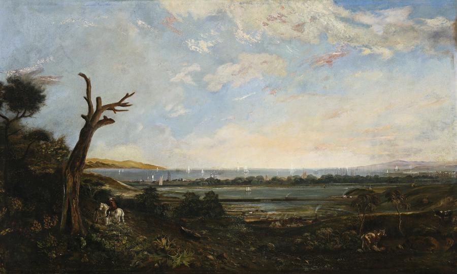
PORT PHILLIP BAY, FROM THE SOUTH WEST CORNER OF ROYAL PARK ACROSS BATMAN'S SWAMP (WEST MELBOURNE SWAMP) TO PORT MELBOURNE WITH WILLIAMSTOWN TRAIN CROSSING, c.1860s
J.S. CALDER
oil on canvas
94.0 x 155.5 cm
signed lower right: J.S. CALDER
Private collection, Melbourne
Christie's, Melbourne,1 March 1973, lot 250
Private collection
Christie's, Sydney, 22 October 1975, lot 376
Private collection
Leonard Joel, Melbourne, 27 May 1981, lot 906
Private collection, Melbourne
Illus. on Picture Victoria, State Library of Victoria, Melbourne,
This 1860s view of Port Phillip Bay from Royal Park depicts an exciting moment in Melbourne's early development. The clear blue lagoon of Batman's Swamp and the surrounding meadows and tea tree thickets are yet to be despoiled, dozens of sailing ships anchored in the bay, still bringing diggers to the goldfields, with a building boom gradually filling Sandridge (Port Melbourne) and Williamstown. The main part of the city is out of view over the hills on the left, leaving a rural idyll with only scattered traces of the incursion of civilisation.
The rider looks down on an Aboriginal man holding a spear and wearing a possum skin cloak. Aboriginal people still congregated around the settlement, but by 1860 they were a rare site in Melbourne with just 28 Bunurong and Woiwurrung (of which the Wurundjeri were the main clan) recorded in the census before they were removed to Coranderrk in 1863.
Royal Park was an important Wurundjeri camping ground, described by John Batman as, 'thinly timbered with gum and wattle and she-oak'. The Park originally comprised 2,500 acres (625 hectares), and was created by Governor Latrobe on his last day in Melbourne in 1854. Latrobe had previously limited land sales within five miles of Melbourne to preserve the town reserve. It became an important gathering place for Melburnians, such as when a vast crowd watched Burke and Wills set out on 20 August 1860 to cross the continent from south to north. It would be interesting to know if Calder painted his scene after this event.
The view is from the high ground near North Melbourne, possibly around Canning and Shiel Streets, looking south to Port Phillip Bay with the Williamstown promontory on the right, Batman's Hill in the left distance, and Arthurs Seat on the horizon (just above the rider). Cattle graze around the swamp margins, where a decade later pumps were installed and a channel dug to drain the swamp and the Moonee Moonee Chain of Ponds, now Moonee Ponds Creek.
The low land between Melbourne and Williamstown rose from the swamp to Batman's Hill and Flagstaff Hill, where a grassy woodland of eucalypts, wattles and she oaks was considered 'the prettiest part of Melbourne'. The dead stag on the left was probably a Yellow Box (Eucalyptus melliodora) or Yellow Gum (Eucalyptus leucoxylon). The foreground vegetation is imaginative, but may represent Tree Violet (Hymenanthera dentata) and Flax Lily (Dianella spp.) on the escarpment. This is now the Docklands, rail yards and port area.
Sails appear to glide through the trees in the distance, but this is where the Yarra ran on its tortuous course, lined with Swamp Paperbark (Melaleuca ericifolia) along Humbug Reach and Fishermen's Bend before excavation of the Coode Canal straightened and widened it.
A number of historically accurate features are shown, including the causeway of the Geelong and Williamstown Railway with its bridge over what is now Moonee Ponds Creek, the chimneys and bottle shaped kilns of the North Melbourne pottery just in front of the swamp. Tanneries and houses are along Flemington Bank (the swampy margins on Moonee Ponds Creek) and Kensington Hill. The 1852 Point Gellibrand Lighthouse in the centre distance stands prominently in its coat of whitewash. It was converted to a timeball tower in 1858, and then back to a lighthouse in 1925, then reverted to a timeball in the 1980s restoration, but with bare bluestone rather than whitewashed. The buildings along Nelson Place to the right of the lighthouse include the three storey Oriental Hotel (built 1854 as Cox's Family Hotel then renamed the Barkly Arms Hotel in 1857), which still stands today but is proposed for demolition.
GARRY VINES
Senior Historical Archaeologist, Biosis
Research to date has been unable to reveal the identity of the artist J.S. Calder. A past attribution to the Tasmanian surveyor James Erskine Calder (1808 - 1882) which appears on the painting's title plaque is erroneous.