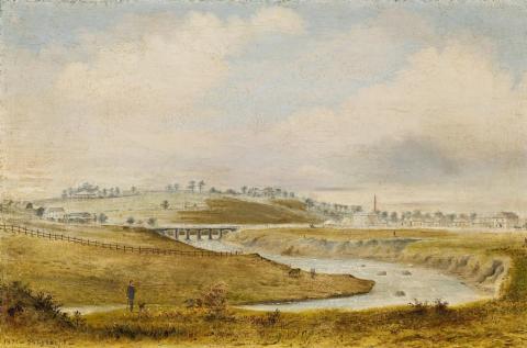
VIEW ON THE CAMPASPE - FROM THE NORTH EAST OF PIPER ST. BRIDGE (KYNETON), 1871
P.J. Lysaght
oil on canvas
35.0 x 52.0 cm
signed and dated lower left:1871 - P. Lysaght -
inscribed verso: View on the Campaspe / from the N.E.of Piper St. Bridge
The Berry Collection, Melbourne
Private collection, Victoria
The party of explorer Thomas Mitchell crossed the river at or near the future town site in 1836 and named it the 'Campaspe', after one of Alexander the Great's courtesans. The first squatter, Charles Ebden, arrived in 1837 and settled on the eastern side of the Campaspe River. Other squatters followed. The first 'permanent building' in Kyneton was erected in 1843. The future Kyneton was surveyed in 1846 as a camping place for teamsters headed to Bendigo. It was chosen as a town site in 1848 and surveyed in 1849 to serve as a centre of law and administration in place of the earlier Carlsruhe settlement to the immediate south. At that time there were a few slab buildings and huts. It was named after the English village of Kineton in Herefordshire (now Kington).
In 1851 with the official announcement of the discovery of gold, Kyneton developed rapidly as a gateway to and supply centre for the goldfields of Clunes, Castlemaine and Bendigo. Kyneton developed as a major agricultural town, and general prosperity resulted in a building boom that saw bluestone quarrying become a substantial industry. Kyneton was proclaimed a municipality as early as 1857. In 1862 the rail link from Melbourne arrived, further boosting the town's fortunes.
This painting is a rare and important topographical record of early Kyneton. Piper Street was the town's original commercial centre and is now a historical precinct. On the hill to the left middle-ground is Kyneton Hospital's main double-storey bluestone building (dating from 1854-56 and built to the design of architect Gabriel Fleck) which still exists, but all associated and adjoining buildings were demolished in 2008. The Campaspe River runs along the western and southern edges of town.
The building on the right with the tall chimney is Argyle's Steam Flour Mill (c.1854). An outline of this building is still in the ground today, but the building itself was demolished in the 1930s. The double-storey house to the right of the mill is Argyle's residence, known as 'Rock House', built c1853-54 for pastoralist Edward Argyle, on the banks of the Campaspe River. It was a substantial bluestone house, colonial Georgian in style, but was burnt out in 2003 leaving only the facade .
